

© 2026 All Rights Reserved. 粤ICP备14051456号
2023-07-31
View:17
Satellite altimetry has been widely used for inland water monitoring and modeling in the present decade, and up to now, it is the only way to survey inland water elevation at a global scale. However, due to its ocean-oriented nature, it faces many challenges over inland waters.
Compared to the open ocean surface, which is relatively smooth and predictable, the topographic surface of land is rough and less predictable. Therefore, over land, it is difficult to correctly position the recording window (the so-called range window) for the onboard tracking and control systems (Figure 1). The narrow range window (usually 30–60 m) may cause data loss or degraded measurements in coastal areas and rugged landscapes. This is sometimes the case over lakes, reservoirs, and rivers that are usually located in valleys.
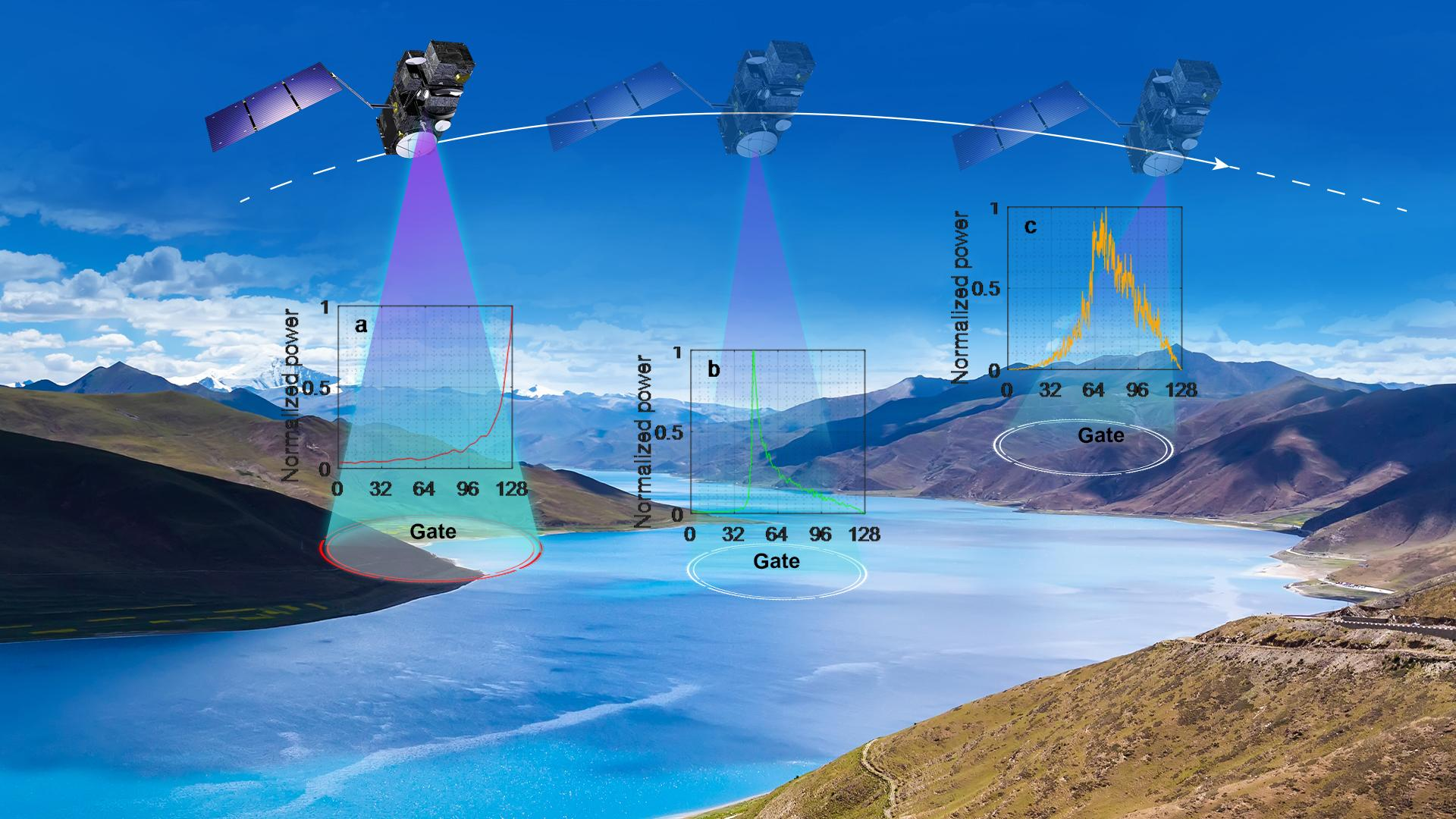
How has satellite altimetry performance over inland mountainous lakes progressed in the past three decades?
Assistant Professor Liguang Jiang’s research group from the School of Environmental Science and Engineering (ESE) at the Southern University of Science and Technology (SUSTech) has exclusively investigated the performance (both Level 1 and Level 2 data) of different satellite missions over mountainous lakes and published their findings in two journals.
Their work has devoted an in-depth inter-comparison of multiple radar altimeters over mountainous lakes, and with this, aims to assess the progress of inland water altimetry, especially in terms of data acquisition and quality. It intends to provide valuable information for the hydrology community as well as future altimetry missions, especially for inland altimetry improvements.
Their first paper, entitled “Improvements in mountain lake monitoring from satellite altimetry over the past 30 years – lessons learned from Tibetan lakes”, has been published in Remote Sensing of Environment, a prestigious journal serving the Earth observation community with the publication of results on the theory, science, applications, and technology of studies contributing to advance the science of remote sensing.
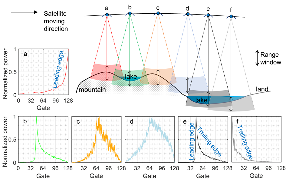
Figure 1. Illustration of scenarios of range window position and corresponding waveform acquired. Note the range window is positioned in time and, therefore, cannot be below the earth’s surface. Here it is simply used for illustration. In cases (a) and (f), the range window is set too early and too later in time, respectively, to capture the full echo reflected by the lake’s surface. In (d), the range window is set way too high or too early in time to record any signal from the lake.
Prof. Jiang’s group also investigated the value of the near real-time satellite product for detecting extreme hydrological events, such as floods. Usually, researchers only use non-time critical product (about one month delay after). But, if time is a major concern, near real-time product would be of great value. Therefore, they assessed the quality of the near real-time product of the Copernicus Sentinel-3 altimetry at a global scale and demonstrated the great value of the near real-time product of flood detection over the Amazon, Congo, and Brahmaputra rivers.
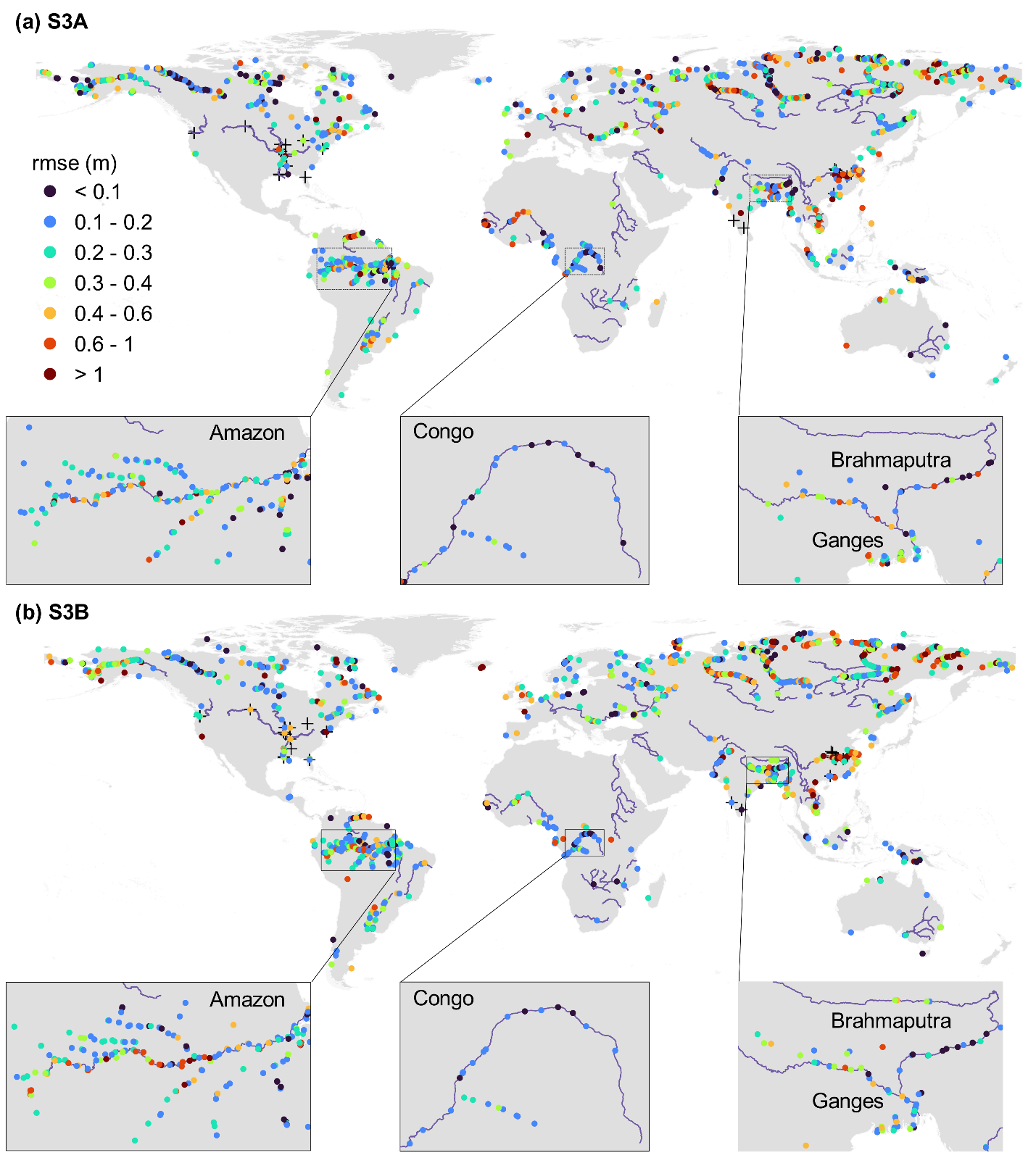
Figure 2. Overview of the virtual stations (VS) evaluated and the RMSE of river WSE time series between NRT and NTC products for (a) Sentinel-3A and (b) Sentinel-3B. Crosses indicate the locations of in-situ gauging stations. Insets show the zoom-in view of evaluation over three large rivers.
Their second paper, which presents this work, has been published in Environmental Research Letters under the title of “Near real-time altimetry for river monitoring—a global assessment of Sentinel-3”.
Asst. Prof. Liguang Jiang from the School of ESE at SUSTech is the first and corresponding author of these papers.
This work was supported by the Start-Up Fund of SUSTech, CRSRI Open Research Program, and the Danida Fellowship Center.
Paper links:
Remote Sensing of Environment: https://doi.org/10.1016/j.rse.2023.113702
Environmental Research Letters: https://doi.org/10.1088/1748-9326/acdd16
2026-03-10
2026-09-08
A delegation of 13 students from Southern University of Science and Technology (SUSTech), Zhejiang University and the University of Science and Technology of China (USTC), accompanied by four SUSTech faculty members including including two affiliated with the State Key Laboratory of Soil Pollution Control and Safety, concluded a 12-day summer school at Flinders University in August, 2026, hosted by the University’s National Centre for Groundwater Research and Training (NCGRT).Throughout the program, the students participated in a wide range of educational activities covering water resources, environmental health, groundwater modeling, managed aquifer recharge, salinity management, mining sites management, virtual reality hydrology, and nature-based solutions for surface water, groundwater and soil pollution.A highlight of the visit was a series of field trips showcasing South Australia’s unique natural environments. These included an overnight excursion to a global showcase of integrated surface and groundwater management exemplified by the Murray-Darling Basin. Visits to the St Kilda Mangroves highlighted ecohydrological approaches to coastal mangrove conservation. While Hallett Cove featured the most famous glacial striation on pre-Cambrian rocks. Happy Valley Reservoir, Oaklands Wetland, and Port Willunga Beach, with their wildlife, water management and well-exposed sedimentary rock formations, left strong impressions on our students. Students also attended research seminars and explored Flinders University’s teaching and research facilities.This summer school provided an excellent opportunity for students to engage with Flinders University staff, students, and researchers, experience Australian approaches to soil and groundwater pollution control and safety research, and strengthen the institutional ties between SUSTech and Flinders University, while fostering international connections and cross-cultural learning. The visit was made possible through a combination of support provided by SUSTech and the Fundamental and Interdisciplinary Disciplines Breakthrough Plan of the Ministry of Education of China(JYB2025XDXM909).During the visit, Chair Professor Yan ZHENG from SUSTech delivered a research seminar on arsenic detection in the developed and developing world. Flinders University noted that its academic community was privileged to learn from her expertise.SUSTech expresses its gratitude for the incredible partnership with Flinders University at the conclusion of the program.
2026-04-22
On April 22, the Frontiers Planet Prize announced its list of 25 National Champions for 2026. Hong WANG, a 2025 graduate of the School of Environmental Science and Engineering at the Southern Universi
2026-04-20
On the morning of April 17, 2026, a delegation from Flinders University (Australia), led by Professor Colin Stirling, President of Flinders University, visited the Southern University of Science and T
2026-04-08
Hydrological models are foundational tools for water resource management, agricultural planning, flood and drought mitigation, and ecosystem protection. A long-standing challenge in hydrology is devel
 |