

© 2026 All Rights Reserved. 粤ICP备14051456号
2026-04-08
View:57
Hydrological models are foundational tools for water resource management, agricultural planning, flood and drought mitigation, and ecosystem protection. A long-standing challenge in hydrology is developing models that generalize reliably across different regions and time periods, particularly in ungauged catchments where no observational data are available and in environments undergoing rapid change due to human activity. Conventional approaches rely on static catchment attributes such as topography, land use, and soil type to characterize individual basins, but these multi-year averages capture only a limited set of catchment features and fail to reflect the dynamic reality of land surface conditions, limiting model performance precisely where accurate prediction is most needed.
A research team led by Professor Yi Zheng from the School of Environmental Science and Engineering at the Southern University of Science and Technology (SUSTech) has addressed this challenge by introducing a novel data source—satellite embeddings generated by Google's AlphaEarth Foundations model—into rainfall-runoff simulation for the first time. Their findings, published in Geophysical Research Letters under the title "Foundation-scale satellite embeddings reframe hydrological generalization as a representation problem," demonstrate that the key to improving hydrological model generalization lies not in designing more complex model architectures, but in providing models with richer, more dynamic representations of catchment characteristics.
Released in 2025, Google's AlphaEarth Foundations model integrates optical imagery, synthetic aperture radar, and terrain data through deep learning to encode complex surface information into unified, low-dimensional numerical representations known as embeddings. These embeddings are updated annually at approximately 10-meter resolution across the globe, with each pixel represented as a 64-dimensional vector—effectively creating a time-varying, structured "digital profile" for every location on Earth's surface. As a novel land surface representation product, its potential for Earth system modeling tasks had not yet been systematically evaluated.
The research team constructed a hybrid-attribute deep learning hydrological model that fuses traditional static attributes with AlphaEarth satellite embeddings (Figure 1) and systematically validated the framework across 455 catchments in Australia (Figure 2), spanning diverse climatic zones and land use conditions.
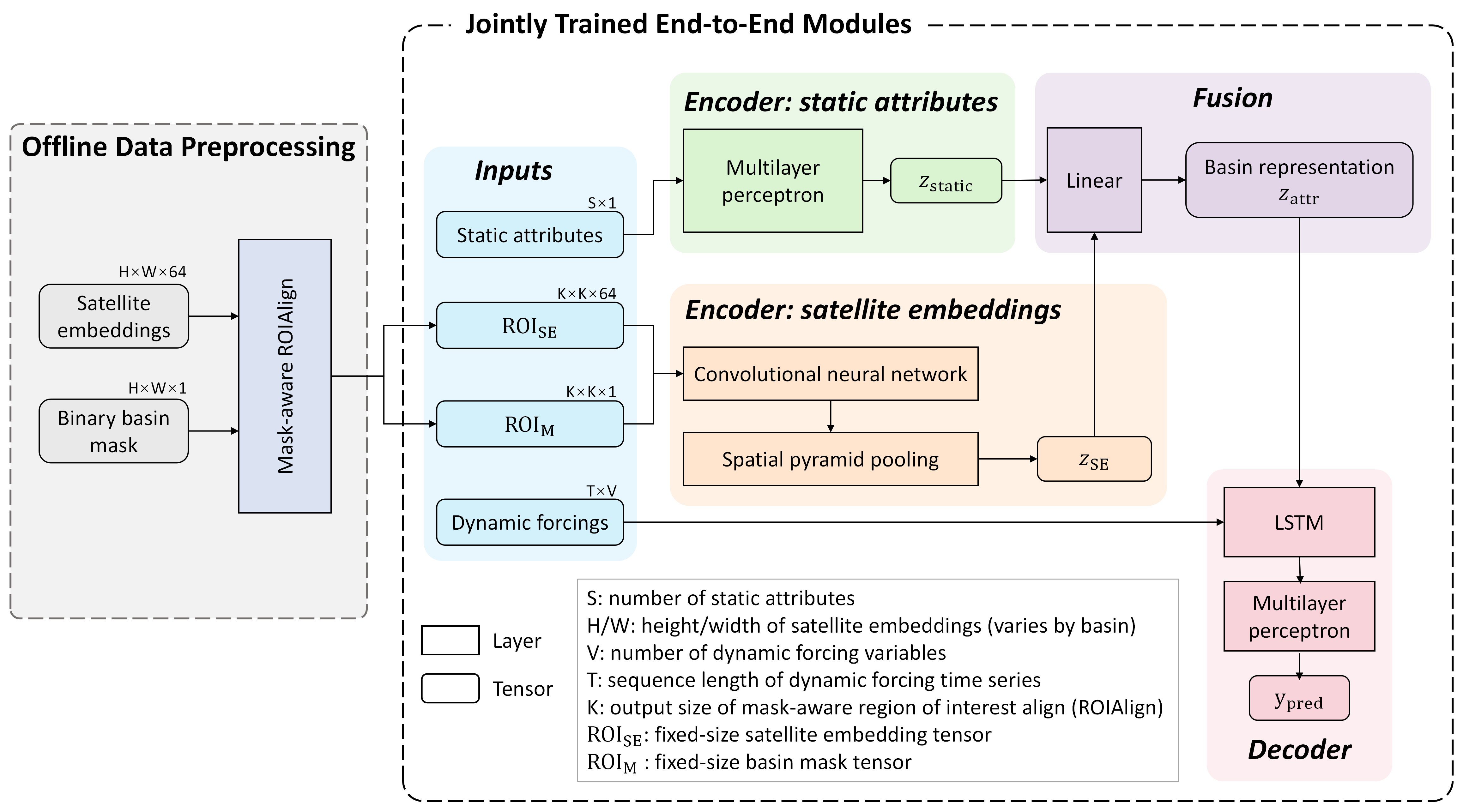
Figure 1: Hybrid-attribute deep learning hydrological model integrating traditional static attributes with satellite embeddings
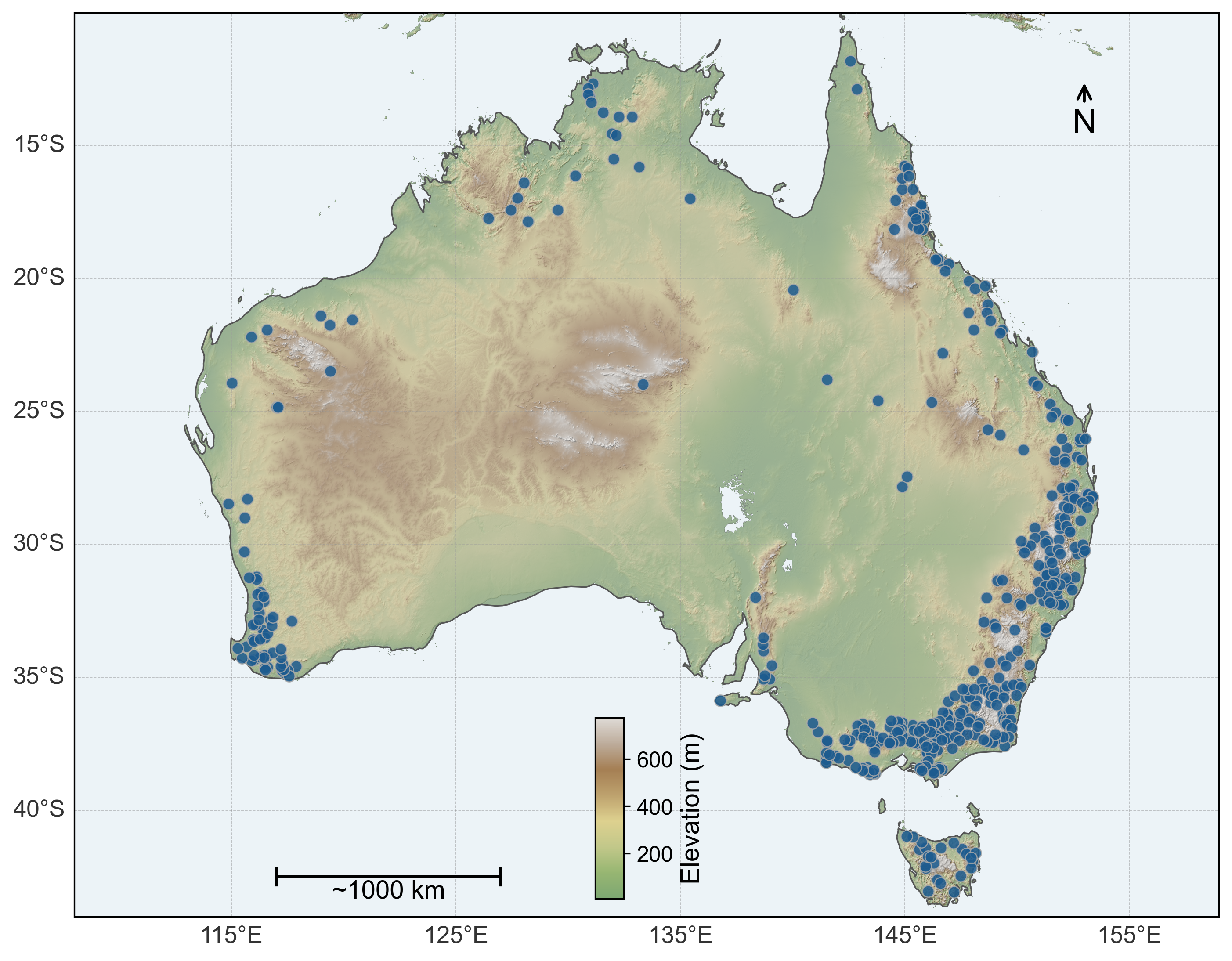
Figure 2: Spatial distribution of the 455 study catchments in Australia
The study reveals that the accuracy improvements brought by satellite embeddings are not uniformly distributed but are closely tied to the intensity of human disturbance within a catchment. In the most heavily disturbed catchments, incorporating satellite embeddings reduced simulation errors by an average of 11.5%, compared with only 4.6% in low-disturbance catchments. In catchments with the highest proportion of agricultural land, error reduction reached 12.5%, while those dominated by forest cover saw only a 1.3% improvement. This pattern indicates that the limited temporal generalization of current models stems largely from a mismatch between static attributes and actual land surface conditions: when catchments undergo rapid change due to human activity, fixed representations fail to reflect their true state, weakening model inference. In contrast, the annually updated satellite embeddings enable models to perceive recent catchment conditions, with the greatest benefits emerging where surface change is most dramatic.
The study further uncovers a critical spatial generalization challenge. When relying solely on static attributes, certain catchments appear as "islands" in the feature space (Figures 3a, 3c), with no similar catchments in the training set available for reference. This representational isolation makes effective extrapolation nearly impossible, causing model performance in these basins to approach near-failure (Figure 3d). The introduction of satellite embeddings reveals previously hidden similarities between catchments, reintegrating these isolated basins into the model's transferable learning domain (Figures 3b, 3c). Importantly, the catchment similarity structures reconstructed through embeddings align more closely with hydrological similarity computed from physical characteristics (Figure 3e), suggesting that the improvements, at least in part, reflect genuine hydrological patterns rather than mere statistical fitting.
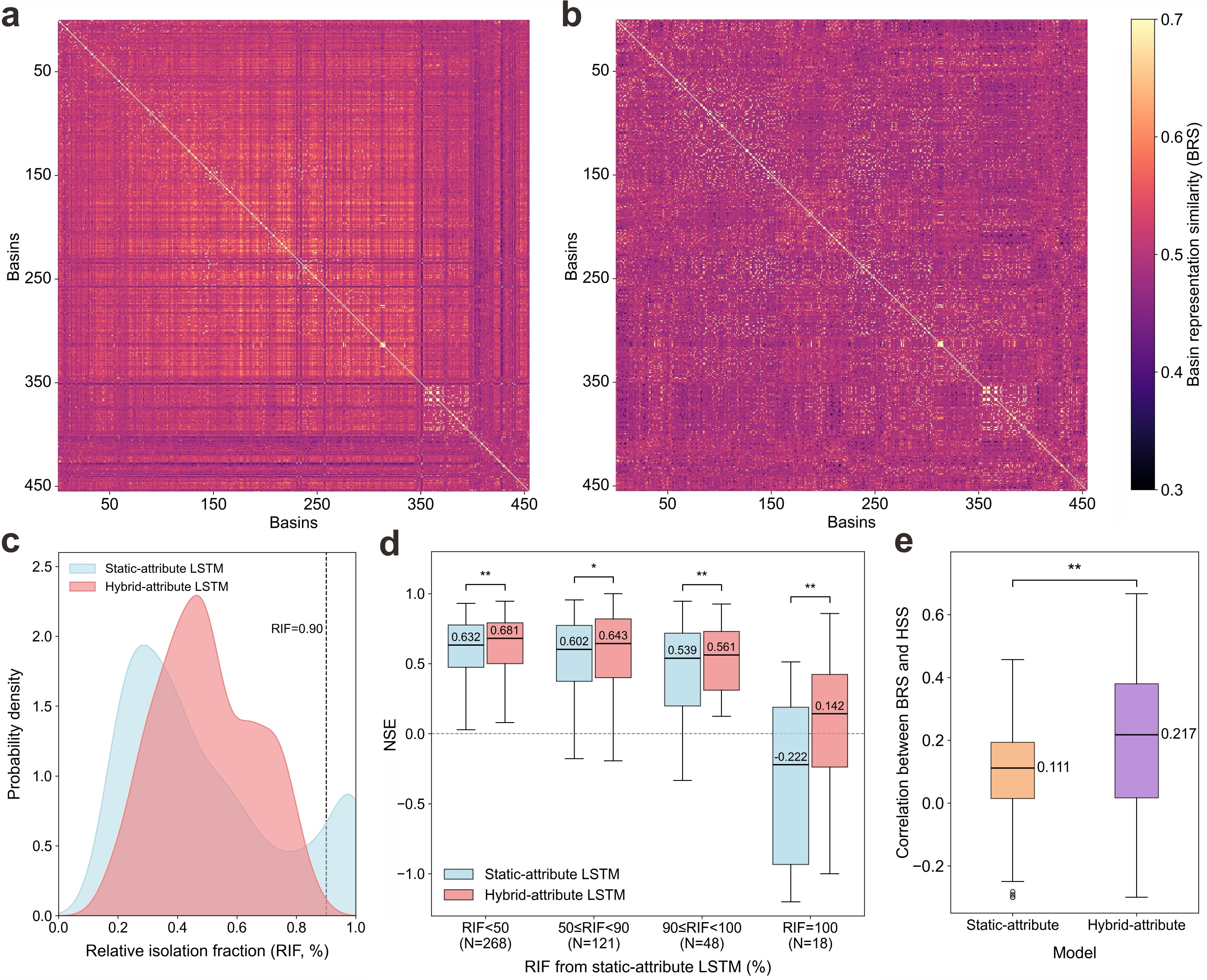
Figure 3: Effects of satellite embeddings on catchment feature space and model spatial generalization
This work demonstrates that hydrological model generalization in changing environments is constrained in both temporal and spatial dimensions, and that the current bottleneck lies more in catchment representation than in model architecture. Rather than pursuing incremental accuracy gains through ever-more-complex models, improving how land surface information is represented may offer a more fundamental pathway toward robust cross-regional, cross-temporal simulation. The study also provides direct validation of AlphaEarth satellite embeddings for Earth system modeling, demonstrating that foundation-model-driven data representations have the potential to serve as a new bridge connecting Earth observation with process-based modeling.
Doctoral student Zhigang Ou from the School of Environmental Science and Engineering at SUSTech is the first author. Professor Yi Zheng serves as the corresponding author, with SUSTech as the sole affiliated institution.
Paper Link: https://doi.org/10.1029/2025GL121604
2026-03-10
2026-09-08
A delegation of 13 students from Southern University of Science and Technology (SUSTech), Zhejiang University and the University of Science and Technology of China (USTC), accompanied by four SUSTech faculty members including including two affiliated with the State Key Laboratory of Soil Pollution Control and Safety, concluded a 12-day summer school at Flinders University in August, 2026, hosted by the University’s National Centre for Groundwater Research and Training (NCGRT).Throughout the program, the students participated in a wide range of educational activities covering water resources, environmental health, groundwater modeling, managed aquifer recharge, salinity management, mining sites management, virtual reality hydrology, and nature-based solutions for surface water, groundwater and soil pollution.A highlight of the visit was a series of field trips showcasing South Australia’s unique natural environments. These included an overnight excursion to a global showcase of integrated surface and groundwater management exemplified by the Murray-Darling Basin. Visits to the St Kilda Mangroves highlighted ecohydrological approaches to coastal mangrove conservation. While Hallett Cove featured the most famous glacial striation on pre-Cambrian rocks. Happy Valley Reservoir, Oaklands Wetland, and Port Willunga Beach, with their wildlife, water management and well-exposed sedimentary rock formations, left strong impressions on our students. Students also attended research seminars and explored Flinders University’s teaching and research facilities.This summer school provided an excellent opportunity for students to engage with Flinders University staff, students, and researchers, experience Australian approaches to soil and groundwater pollution control and safety research, and strengthen the institutional ties between SUSTech and Flinders University, while fostering international connections and cross-cultural learning. The visit was made possible through a combination of support provided by SUSTech and the Fundamental and Interdisciplinary Disciplines Breakthrough Plan of the Ministry of Education of China(JYB2025XDXM909).During the visit, Chair Professor Yan ZHENG from SUSTech delivered a research seminar on arsenic detection in the developed and developing world. Flinders University noted that its academic community was privileged to learn from her expertise.SUSTech expresses its gratitude for the incredible partnership with Flinders University at the conclusion of the program.
2026-04-22
On April 22, the Frontiers Planet Prize announced its list of 25 National Champions for 2026. Hong WANG, a 2025 graduate of the School of Environmental Science and Engineering at the Southern Universi
2026-04-20
On the morning of April 17, 2026, a delegation from Flinders University (Australia), led by Professor Colin Stirling, President of Flinders University, visited the Southern University of Science and T
2026-04-08
Hydrological models are foundational tools for water resource management, agricultural planning, flood and drought mitigation, and ecosystem protection. A long-standing challenge in hydrology is devel
 |