China is an active participant in global climate governance and insists on promoting CO2 mitigation. General Secretary Xi Jinping put forward the ambitious goal of striving to achieve carbon neutrality by 2060 at the 75th United Nations General Assembly.
Recently, Chair Professor Junguo Liu’s research group from the School of Environmental Sciences & Engineering at the Southern University of Science and Technology (SUSTech), in collaboration with scholars from the University of Hong Kong (HKU) and Michigan State University, published findings for a new method that is used to extract high-resolution drainage network. The paper, entitled “Basin-scale high-resolution extraction of drainage networks using 10-m Sentinel-2 imagery” was published in Remote Sensing of Environment, a renowned academic journal that focuses on remote sensing studies.
Extraction of drainage networks is an important element of river flow routing in hydrology and large-scale estimates of river behaviors in Earth sciences. Emerging studies with a focus on greenhouse gases reveal that small rivers can contribute to more than half of the global carbon emissions from inland waters (including lakes and wetlands). However, large-scale extraction of drainage networks is constrained by the coarse resolution of observational data and models, which hinders assessments of terrestrial hydrological and biogeochemical cycles.
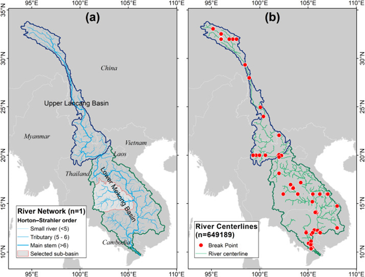
Figure 1: (a) Lancang-Mekong River networks extracted in this study. (b) State-of-the-art Landsat-based river centerlines extraction (GRWL) in the study area with breakpoints (river centerline disconnections).
Recognizing that the Sentinel-2 satellite can detect surface water up to a 10-m resolution over large scales, they proposed a new method named Remote Sensing Stream Burning (RSSB) to integrate high-resolution observational flow location with coarse topography to improve the extraction of the drainage network. In RSSB, satellite-derived input is integrated in a spatially continuous manner, producing a quasi-bathymetry map where relative relief is enforced, enabling a fine-grained, accurate, and multitemporal extraction of the drainage network. RSSB was applied to the Lancang-Mekong River basin to derive a 10-m resolution drainage network, with a significant reduction in location errors as validated by the river centerline measurements.
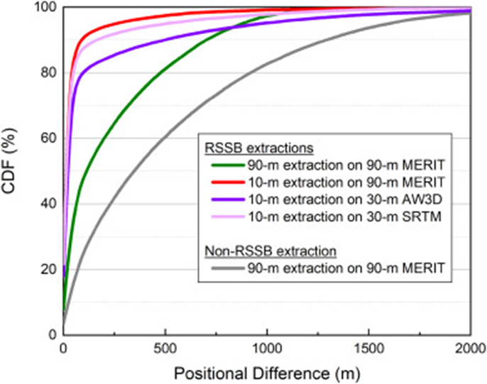
Figure 2: Location errors of river networks generated by the RSSB method and conventional method (non-RSSB). The closer the CDF curve near the top left, the better.
The high-resolution extraction resulted in a realistic representation of meanders and detailed network connections. Furthermore, RSSB enabled a multitemporal extraction of river networks during wet/dry seasons and before/after the formation of new channels. The proposed method is fully automated, meaning that the network extraction preserves basin-wide connectivity without requiring any postprocessing, hence facilitating the construction of drainage network data with openly accessible imagery.
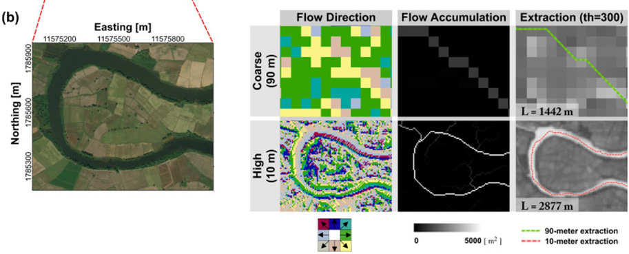
Figure 3: Comparisons of 90-m and 10-m drainage networks, including flow direction, flow accumulation, and extracted river vector.
The RSSB method provides a basis for the accurate representation of drainage networks that maintains channel connectivity, allowing a more realistic inclusion of small rivers and streams. This enables a greater understanding of complex but active exchange between inland water and other related Earth system components.
Zifeng Wang, a doctoral student supported by the joint Ph.D. program between SUSTech and HKU, and Junguo Liu, Chair Professor at SUSTech, are the first and corresponding authors, respectively, of this paper. Jinbao Li and Hongsheng Zhang from HKU, Ying Meng from SUSTech, and Yadu Pokhrel from Michigan State University are the co-authors.
This study was supported by the Strategic Priority Research Program of the Chinese Academy of Sciences, the National Natural Science Foundation of China (NSFC), and SUSTech.
Paper link: https://doi.org/10.1016/j.rse.2020.112281