
New study reveals the dynamics and future trends of the seasonally frozen ground on the Qinghai-Tibet Plateau
Seasonally frozen ground (SFG) is a critical component of the Earth’s surface that affects energy exchange and the water cycle in cold regions. However, the estimation of SFG depth has generally required intensive parameterization thus hindering the assessment in data-scarce regions such as the Qinghai-Tibet Plateau (QTP).
Recently, a group led by Prof. Chunmiao Zheng (School of Environmental Science and Engineering, SUSTech) proposed a simplified yet robust model based on soil heat transport to estimate the temporal dynamics of vertical temperature distribution and SFG depth. Using this approach, the group assessed the historical spatiotemporal patterns of the seasonally frozen ground in the Yarlung Zangbo River Basin on the Qinghai-Tibet Plateau. Further, it projected the future evolution of the SFG depth under climate change scenarios. The results provide an important basis for evaluating the hydrological cycles (e.g., surface water-groundwater interactions) in cold regions under changing climatic conditions.
This work entitled “Dynamics of Seasonally Frozen Ground in the Yarlung Zangbo River Basin on the Qinghai-Tibet Plateau: Historical Trend and Future Projection” was published in Environmental Research Letters, a high-impact journal in environmental science and ecology.

The Yarlung Zangbo River is located in the south of the Qinghai-Tibet Plateau, often referred to as the “Asian Water Tower.” It is the longest plateau river in China and the highest river in the world (Figure 1). The Yarlung Zangbo River provides water resources to support the agricultural and economic development in the region that it flows through. It has formed a huge valley in the south of the Qinghai-Tibet Plateau, an important barley producing area of China. After entering India (where it is called the Brahmaputra River), it flows through a large tea producing area. The Yarlung Zangbo River is also rich in hydropower reserves, second only to the Yangtze River in China. Therefore, the investigation of the water resources and hydrology in the Yarlung Zangbo River Basin is of great significance to the socio-economic development of this region. However, approximately 70% of the Yarlung Zangbo River Basin is covered by seasonally frozen ground (Figure 2). The soil freezes in winter and thaws in summer, altering the hydraulic and thermo-mechanical properties of the soil layer, affecting the regional hydrological cycles and ecosystem functions (e.g., rainfall infiltration, groundwater recharge). Hence, quantifying the spatiotemporal dynamics of the seasonally frozen ground in the Yarlung Zangbo River Basin provides an important basis to evaluate the hydrological cycles in this region and their response to global changes.
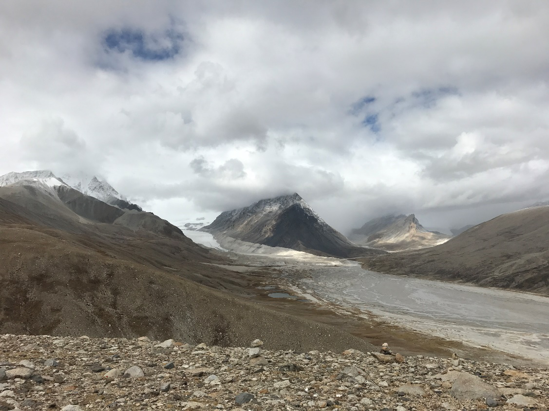 Figure 1. Source region of the Yarlung Zangbo River (a.s.l. 5500 m, photo by Chunmiao Zheng)
 Figure 2. Spatial distribution of the seasonally frozen ground in the Yarlung Zangbo River Basin
Prof. Chunmiao Zheng’s group established a ground temperature transfer model and investigated the dynamics of soil temperature at different depths. The maximum frozen depth is then defined as the maximum soil depth with temperature lower than 0 ◦C. This model is termed the “GT-SFG depth” model (GT and SFG stands for ground temperature and seasonally frozen ground, respectively). They first calibrated the “GT-SFG depth” model using the measure ground temperature and SFG depths at meteorological stations (Figure 3). Then, they assessed the spatiotemporal patterns of the SFG depths during the historical period (1980-2010) for the entire Yarlung Zangbo River Basin using the (adjusted) GLDAS surface temperature data as model inputs (Figure 4). The impacts of soil type, soil moisture, and spatial heterogeneity of vegetation on the soil thermomechanical properties were considered as well. Finally, the authors made future projections for the seasonally frozen ground in the Yarlung Zangbo River Basin under different climate change scenarios using climate products of CMIP5 (Figure 5). The results demonstrate that the SFG depth in the Yarlung Zangbo River Basin has decreased during the historical period due to climate warming with higher rates of decrease in the northwest than in the southeast. This study projected that the seasonally frozen ground in the Yarlung Zangbo River Basin will continue to degrade in the future. If not considering the transition of permafrost to seasonally frozen ground, the current seasonally frozen ground in the Yarlung Zangbo River Basin is likely to disappear by 2180 under the RCP 8.5 climate change scenario (with the basin average SFG depth equal to ~0.1m).
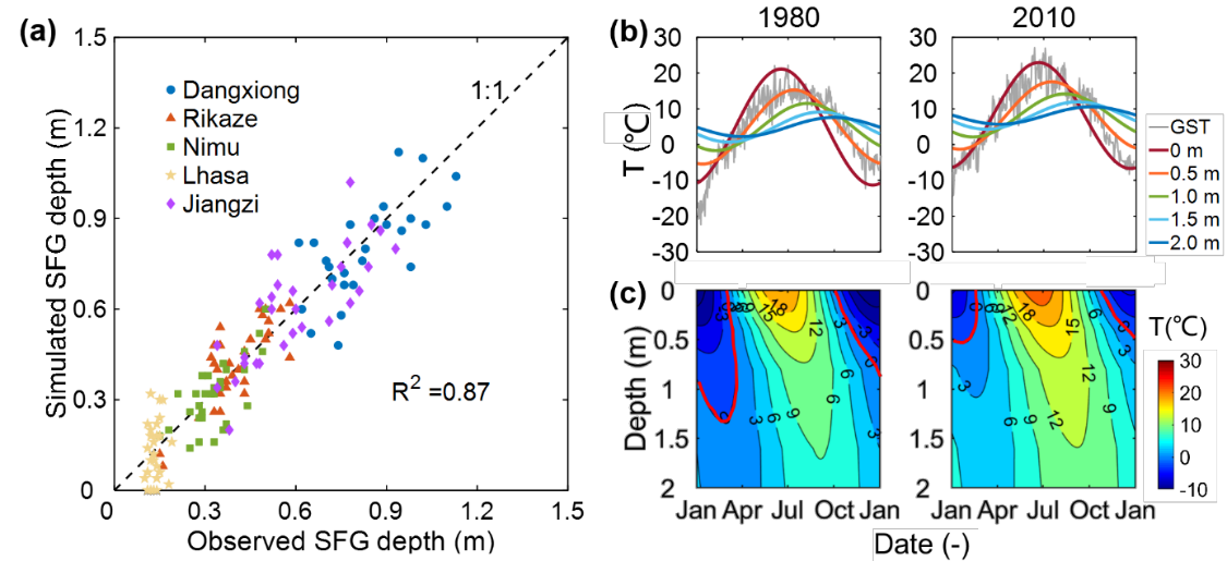 Figure 3. The “GT-SFG depth” model calibration and temporal dynamics of ground temperature at different depths at the Dangxiong meteorological station.
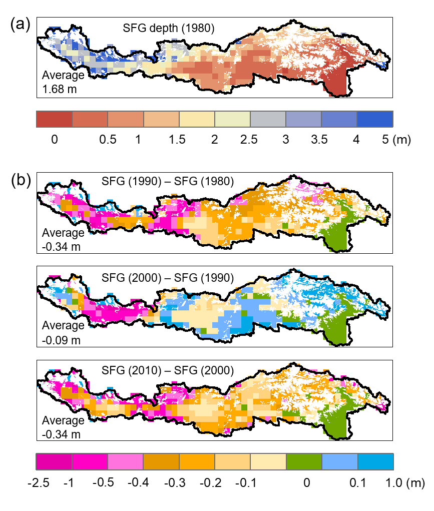 Figure 4. (a) Spatial distribution of SFG depth in 1980; (b) Decadal changes of SFG depth from 1980 to 2010.
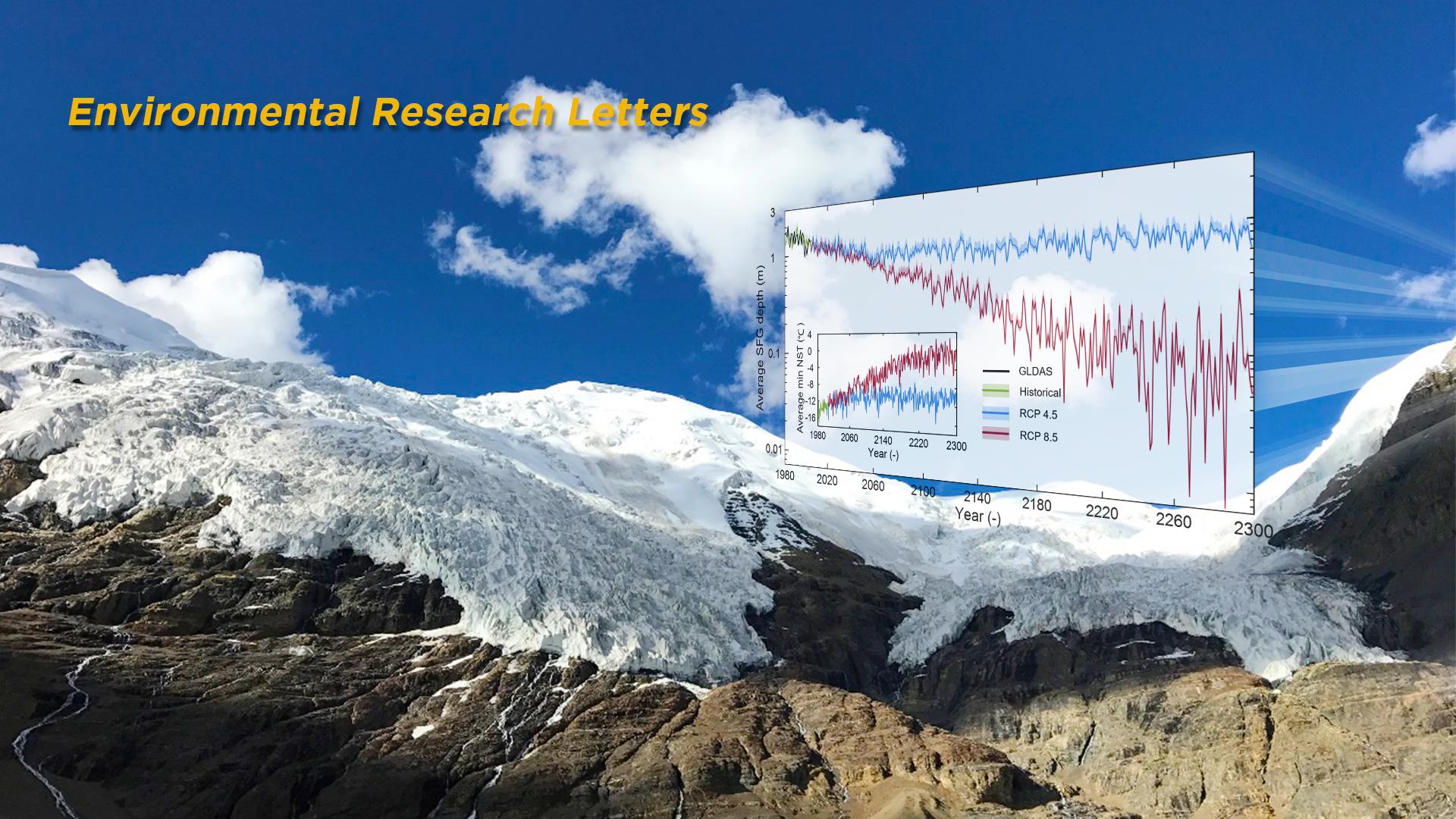
 Figure 5. Temporal dynamics of simulated basin average SFG depth in the Yarlung Zangbo River Basin from 1980 to 2300. The average SFG depths were evaluated up to the year of 2300 based on projected climate scenarios of RCP 4.5 and RCP 8.5.
The Ph.D. student Fang Ji is the first author of this paper, and Prof. Chunmiao Zheng and Dr. Linfeng Fan are the corresponding authors. The Southern University of Science and Technology is the only corresponding institute. This work was supported by the National Natural Science Foundation of China and the State Environmental Protection Key Laboratory of Integrated Surface Water-Groundwater Pollution Control of China.
Article link:
https://doi.org/10.1088/1748-9326/abb731