
New findings on effect of climate change on hydrology of Tibetan Plateau
The Tibetan Plateau has recently experienced noticeable climate changes. As a consequence, this has changed atmospheric and hydrological cycles and reshaped the local environment. The visible impacts of climate change on the Tibetan Plateau are obvious: increased rainfall, melting glaciers, rising lakes, etc. However, the impacts on the groundwater and the Tibetian people living there have attracted less attention.
A group of scholars from the School of Environmental Science and Engineering at the Southern University of Science and Technology (SUSTech) has recently analyzed the effects of climate change in the Tibetan Plateau. Associate Professor Xingxing Kuang’s team has published five papers in top journals in environmental science such as Environmental Research Letters and Journal of Environmental Management and top journals in hydrological science such as Journal of Hydrology.
The first paper, entitled “Increasing annual streamflow and groundwater storage in response to climate warming in the Yangtze River source region,” was published in Environmental Research Letters. This study selected long-term (1962–2012) streamflow records and permafrost data in the Yangtze River source region to analyze streamflow variations and groundwater storage in response to climate warming.
Their results showed that the main period scales of annual streamflow and winter baseflow are 37 years and 34 years, respectively. The rising air temperature is the primary cause for the increased streamflow instead of precipitation and evaporation. Permafrost thawing and increasing temperature are the direct and indirect causes of the increasing groundwater storage (Figure 1).
These findings are significant in investigating the hydrological processes and water resources management in mountainous alpine regions in response to climate change.
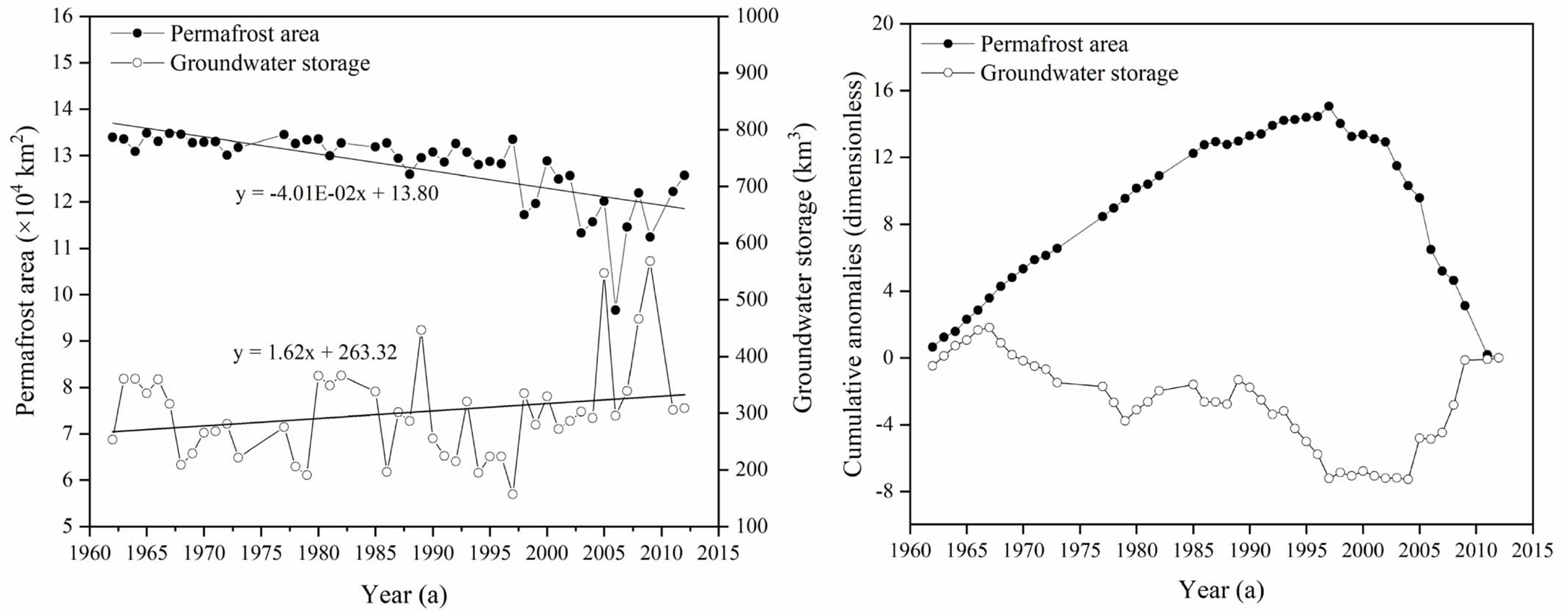
Figure 1. Variations of permafrost area and groundwater storage during 1962–2012
The second paper, entitled “Water quality and health risk assessment of the water bodies in the Yamdrok-Tso basin, southern Tibetan Plateau,” was published in the Journal of Environmental Management.
In this study, Professor Kuang’s team looked at the lake waterbodies’ quality status and health risk. They observed this in the national nature reserve, the Yamdrok-Tso basin, in the southern Tibetan Plateau. They were assessed by 25 water parameters, corresponding pollution index, water quality index, and health risk index.
The group’s results showed that the lake water bodies were at a low pollution level with respect to heavy metal(loid)s. The water quality of most areas met the regulation of the China National Standard for water resources in national nature reserves. Health risk assessment showed that potential hazards existed in this region when the residents are under long-term exposure to the lake water through oral and dermal pathways. Children and adults are mostly exposed to As and F for non-carcinogenic and As for carcinogenic risks.
This study could help to further understand the heavy metal(loid)s mobility and health hazard in the lake water of the southern Tibetan Plateau. Their findings could also contribute to making targeted regulations in the national nature reserves (NNR) for effectively managing water resources.

Figure 2. Water quality status and health risk of the lake water bodies in the Yamdrok-Tso basin, southern Tibetan Plateau
The third paper, entitled “A simple and efficient method for correction of basin-scale evapotranspiration (ET) on the Tibetan Plateau,” was published in Remote Sensing. In this study, the researchers proposed a simple and efficient method to correct basin-scale ET in seven sub-basins on the Tibetan Plateau.
A reasonable, accurate, and corrected ET was obtained on the Tibetan Plateau. The corrected ET improved the correlation coefficients and reduced the biases and root-mean-square errors (RMSEs). The ET on the Tibetan Plateau decreased from southeast to northwest. There was a general increasing trend of ET on the Tibetan Plateau, with an average value of 1.2 mm/yr over the period from 2003–2014 (Figure 3). These results contribute to a better understanding of the hydrological cycle of the plateau.
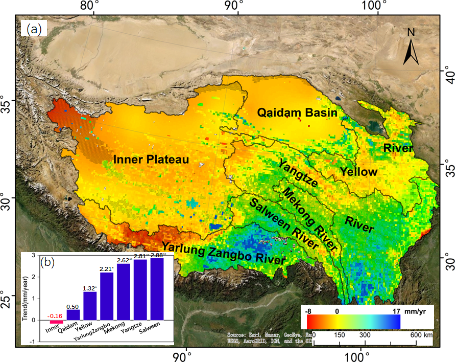
Figure 3. Distribution of corrected ET trends in the sub-basins on the Tibetan Plateau (2003-2014)
The fourth paper, entitled “A preliminary investigation on the climate-discharge relationship in the upper region of the Yarlung Zangbo River basin,” was published in the Journal of Hydrology. This study analyzed the annual and seasonal variability of the river discharge in the upper region of the Yarlung Zangbo River basin. It investigated the climate-discharge relationship and projected the trend of river discharge from 2021 to 2100 using a distributed hydrological model (Soil and Water Assessment Tool, SWAT).
River discharge is one of the key elements of the global water cycle. However, observation and projection of river discharge are still lacking in alpine areas. This research showed that river discharge did not show the same trend as precipitation at either an annual or seasonal scale, which indicates that precipitation might not be the primary source of river discharge (Figure 4).
Meltwater from snow, glacier, and frozen soil could contribute a large percentage of river discharge. The projected river discharge would vary significantly over the years with different changing rates in response to different scenarios of climate change. This study contributes to investigating the unusual climate-discharge relationship that is different from that in the whole river basin.
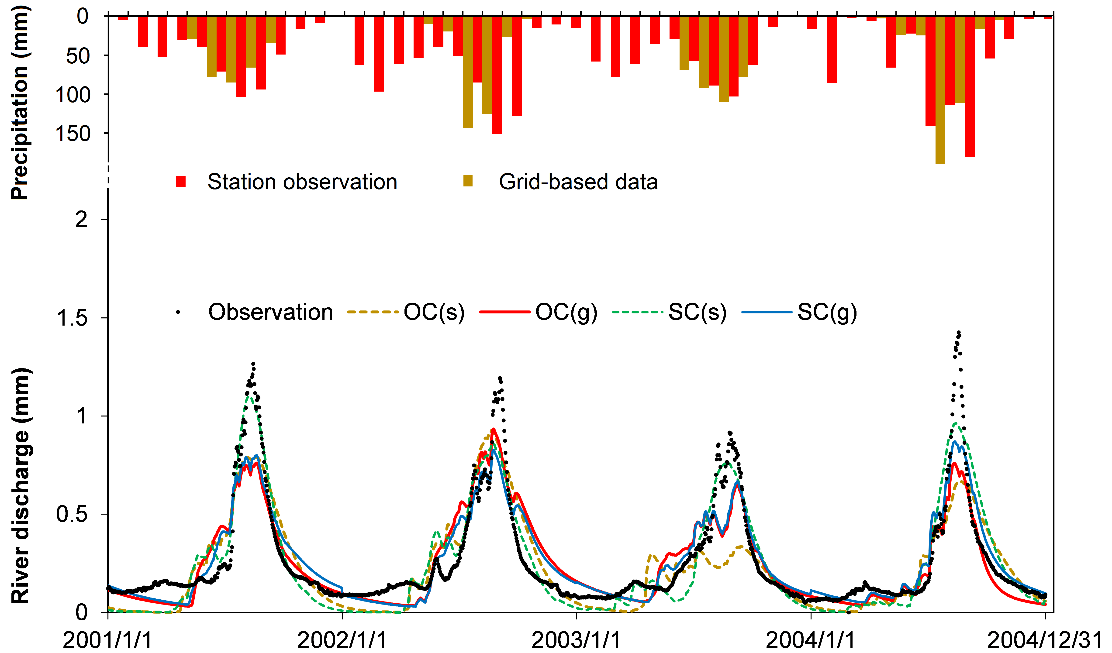
Figure 4. Comparisons of observations (black points) and simulations in both OC and SC cases based on grid-based data (g) and station observations (s)
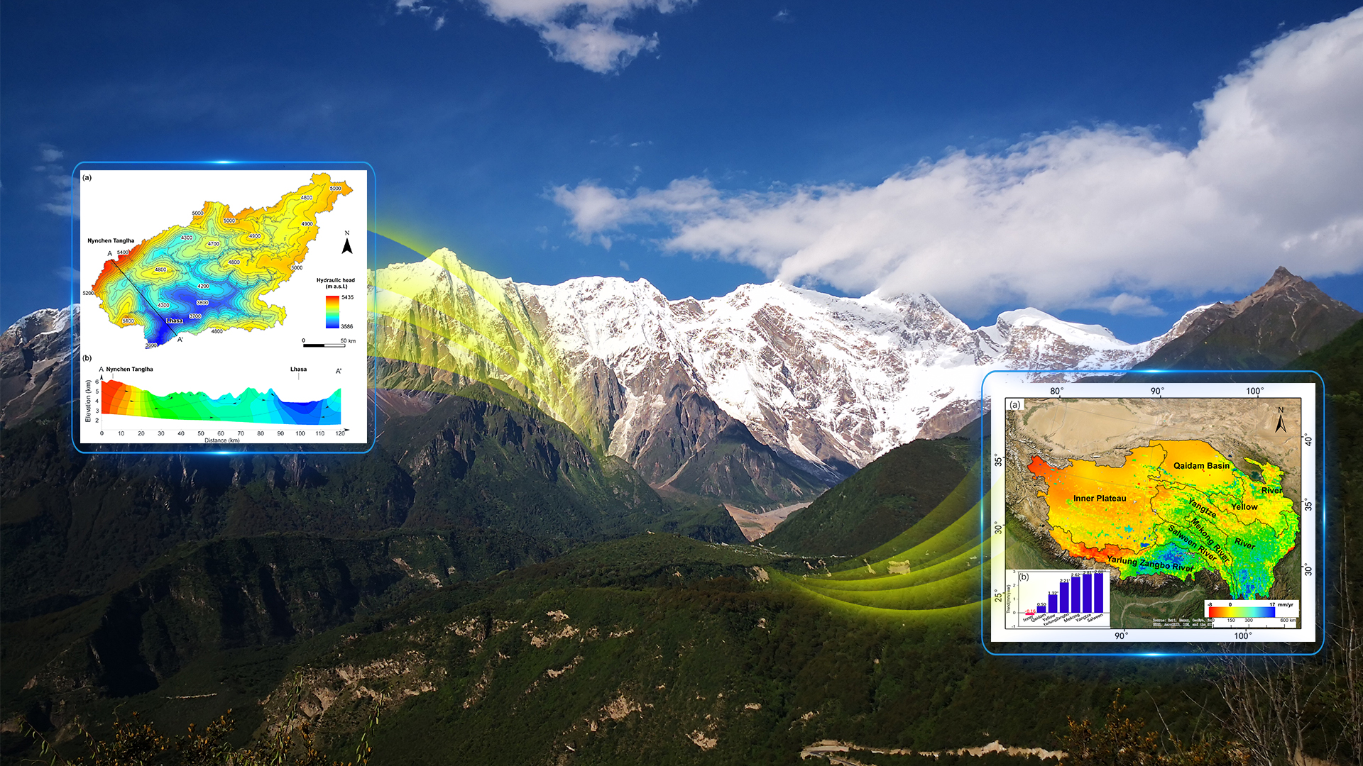
The fifth paper, entitled “Analysis of the groundwater flow system in a high-altitude headwater region under rapid climate warming: Lhasa River Basin, Tibetan Plateau,” was published in the Journal of Hydrology: Regional Studies. Taking the Lhasa River Basin (LRB) as an example, Prof. Kuang’s team developed a numerical groundwater flow model to characterize the groundwater flow pattern and simulate the groundwater’s recharge and discharge.
They also quantified the impact of climate change on the groundwater flow system in the LRB (Figure 5). Results show that more than 80% of the groundwater flows within 300 m below the ground surface. The groundwater flow system is dominated by flow path distances of less than 10 km and between 10 and100 years.
The projected interannual fluctuations of baseflow in the LRB will increase, and the groundwater’s response in mountainous areas to climate change will be more sensitive than in other areas.
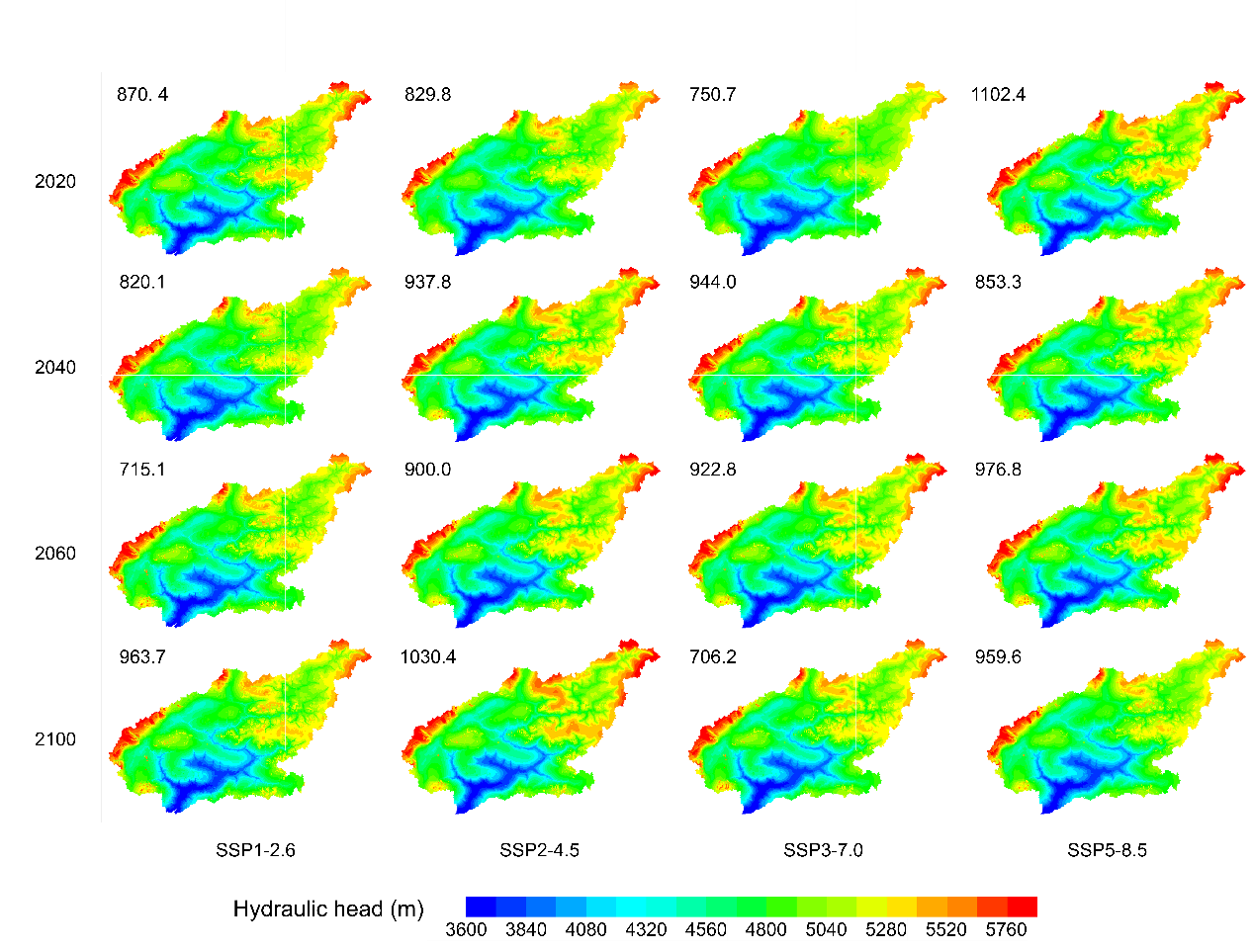
Figure 5. Simulated hydraulic head distributions in the LRB for typical four years (2020, 2040, 2060, 2100) in response to different climate change scenarios
Wenxuan Yi from the China University of Geosciences (Beijing), and Can Wang, Yuqing Feng, Suning Liu, and Jiachang Chen, all members of Prof. Xingxing Kuang’s group at SUSTech, are the first authors of the five papers, in order of their appearance above. Xingxing Kuang is the corresponding author or co-corresponding author for all the papers.
These studies were funded by the National Natural Science Foundation of China (NSFC).
Paper link (In order of appearance above):
Environmental Research Letters: https://iopscience.iop.org/article/10.1088/1748-9326/ac0f27
Journal of Environmental Management: https://www.sciencedirect.com/science/article/pii/S0301479721018028
Remote Sensing: https://www.mdpi.com/2072-4292/13/19/3958
Journal of Hydrology: https://www.sciencedirect.com/science/article/pii/S0022169421011161
Journal of Hydrology: Regional Studies: https://www.sciencedirect.com/science/article/pii/S2214581821001002